Sunday, May 4, 2014

New York Rising

I imagine anyone having serious damage from Superstorm Sandy must be very used to having their patience tried. Government red tape and delays in getting any kind of assistance to those in need have got to be maddening for those affected.

We know some people who live in a two-story house in Massapequa, here on Long Island; it was originally built in 1947 but had been renovated and expanded over the years. They are about a block and a half away from the bay to their south, another block away from a canal to the east, and two blocks from a canal to the west. Their first floor was wiped out during Hurricane Irene, a few years ago, so they had to rebuilt it. When Sandy hit Long Island, it completely destroyed their first floor again.

Early photos by Ken Bausert; later photos by Tim (the homeowner).
Click on any photo to enlarge.


Now, I’m sure there are people saying, “Well, they shouldn’t build homes so close to the water,” and, of course, in a perfect world, that’s correct. But, as in many other areas, homes have long been built in locations that never suffered such catastrophic damage over the course of decades – or even hundreds of years – and it only takes one superstorm to show how vulnerable they can be.

In any case, after fourteen months, this family was finally approved for assistance and they are in the process of raising their house ten feet off the ground. Since we had been in contact with Pat, she informed us of when the work was being done so I spent two days watching – and photographing – the event.


Because the house originally sat on a slab (no basement) there were no first floor joists to lift it from. That required hefty wooden beams to be secured to all the inside wall studs of the first floor so that huge steel girders could be placed (through holes in the walls) under them before being lifted by powerful hydraulic jacks. And, because there were few load-bearing walls in the center of the first floor, massive supports had to be placed under the second floor during the lift to maintain integrity with the first floor walls.
A tricky undertaking!


The new ground level can not be used for “living space” and, of course, the old first floor (now the second floor) must have all new floor joists installed. The oil burner remains on the ground level but must be raised over a yard off the slab so that it will not be damaged unless the water level rises above that height in the event of another storm.


The hydraulic pumping station which distributes pressure to
nine strategically-placed jacks that raise the house.


Each time the house is raised about 12-15 inches, the house must be re-supported
so the jacks can be lowered and repositioned for the next stage of the lift.


Once the house reaches about ten feet,
a new footing must be prepared for a new foundation
before the house can be lowered to its new final position..


Spiral pilings are screwed into the ground
to a depth of ten-feet before the concrete footing can be poured. 


The tops of the pilings can be seen in the photo below
after they have been driven into the ground.


The new footing forms receive rebar to reinforce
the new concrete.


Vertical rebar is added to reinforce the concrete
that will be poured into the foundation forms.


After the foundation is complete, it must set up before
the house can be lowered and attached to it.


With the house finally reattached to the new foundation,
the interior and exterior can be rebuilt.


Friday, January 11, 2013

Long Beach (1-10-13) Sandy Clean-Up

Superstorm Sandy damaged Long Beach,
on Long Island's south shore, very badly.
Many homes, apartments and condos
 are still without electric or heat
and need serious structural repairs.
a 13 to 17-foot storm surge deposited
beach sand over a foot deep throughout
the streets. The boardwalk, originally
built in 1914, has withstood many
hurricanes but Sandy was too much
for it to bear. It was so badly damaged
that it's being demolished and a
new one will be built in its place.

(Click on any photo to enlarge it.)

The extreme west end of the boardwalk
(New York Avenue),
where I used to go with my parents
most summer weekends, when I was a child.

The demolition has progressed about a
quarter-mile east from the extreme west end.


The concrete supports seem to be in
good shape and will probably be reused.


A workman salvages some of the benches
that were bolted to the old boards.


The concrete roof (part of the boardwalk)
on the men's & women's rest rooms
collapsed.


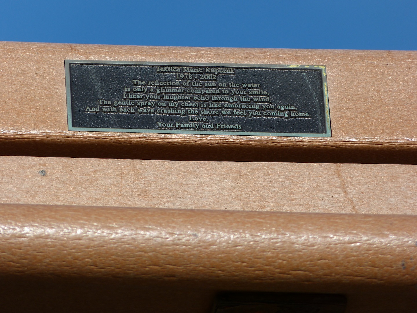
Many benches were donated by local or
past residents in honor of their loved ones.


A 4 x 12 support beam was twisted &
split like kindling by the force of the water.

Sand being cleaned of debris.


Clean sand being put back on the beach.


Trucks distribute the clean sand to
all areas of the beach. 


Sunday, September 25, 2011

The High Line, New York City, 2011


Once upon a time, there existed an elevated rail line that served the lower-to-mid Manhattan west side, and the meat packing industries that flourished there. At certain locations, the rail line actually went through buildings to make loading and unloading the rail cars easier. Completed in 1934, the freight line eventually became obsolete and the southernmost section of elevated track was torn down in 1960. The final train, carrying frozen turkeys, made its run on the remaining track in 1980.


All photos © 2011 by Ken Bausert
unless otherwise noted.

Considered a useless relic and eyesore by many, there were lots of people who wanted to tear the rest of the structure – from just below 14th to 34th Streets – down in the 1990s. Fortunately, city government red tape and lack of funding delayed any demolition and today, the remaining portion of the elevated railway has morphed into New York City’s newest tourist attraction and neighborhood park: The High Line Park. Some unique views of New York City are now enjoyed by residents and visitors alike.

Recently, National Geographic Magazine published a great article on the park in its April, 2011, issue (some of the facts mentioned here are gleaned from that text). The first section of The High Line, running south to north, just west of 10th Avenue, from Gansevoort Street to 20th Street, was opened to the public in June, 2009 (the remaining section, up to 30th Street, opened this past summer of 2011). After reading the Nat Geo piece, Ro and I decided to pay a visit to the park and enlisted some friends to join us; the photos displayed here are from two separate visits.
(As always, click on any photo to enlarge it;
click on it a second time to further enlarge it.)

Above: the northern terminus, at 30th Street.

Above: looking down at 30th Street from the
northern terminus.
What follows are assorted photos from
along the High Line Walk;
I don't think any descriptions are needed.


A concrete paved surface winds its way among wild flowers, trees, and shrubs, just a stone’s throw from old and new buildings housing families and businesses on either side. I understand that some local residents are less than pleased with this new lack of privacy, however.


First visit on May 29, 2011 with (left to right):
Ken, Eileen, Doris, Ro, Jim, and Bob.

Second visit on July 2, 2011 with (left to right):
Ken, Dottie, Bill, Fran, and Fred
(Ro took the photo).

After exiting the High Line at its southern terminus,
it's a short walk west to the Hudson River and
Riverside Park, from where you can see the air
vents for the Holland Tunnel rising
above the river near Canal Street.